Plan Framework
Mobility
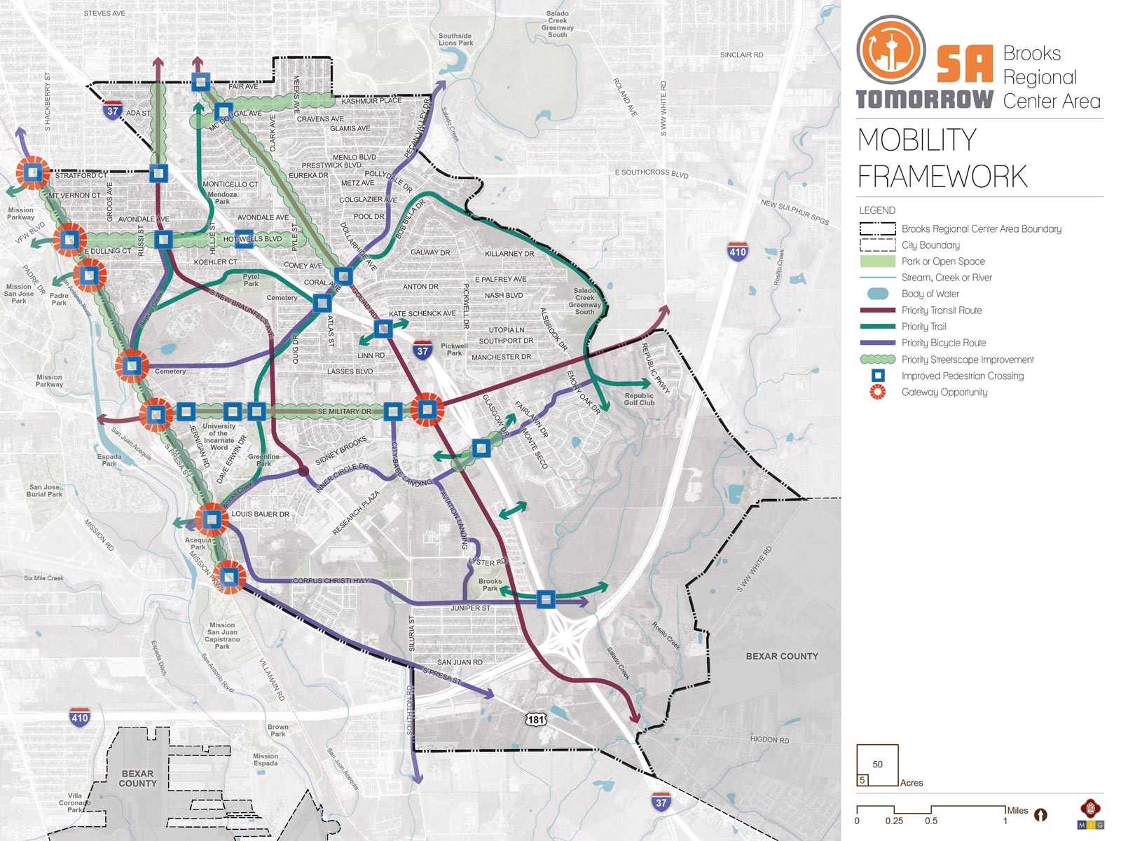
The map below highlights the Mobility Framework identified for the Brooks Regional Center Area. Scroll down to learn more about the vision for Mobility in the Plan Area.
You can also visit the bottom of the page to leave additional feedback.
Background and Transportation Vision
In 2016, the City of San Antonio adopted the SA Tomorrow Multimodal Transportation Plan, to make our city’s transportation system “sustainable, safe, convenient, efficient, and inclusive of all modes.” The plan adopted by City Council established “a shift in focus from moving vehicles to moving people,” in order to manage traffic congestion, and improve transportation choices.
The plan identified two primary and interdependent methods for managing future traffic congestion:
- Develop a land use pattern and policy to promote local trips
- Provide transportation options in addition to vehicles that connect Regional Centers
The SA Tomorrow Multimodal Transportation Plan acknowledged that we cannot build our way out of congestion, and that the Comprehensive Plan, and associated land use plans, are a primary opportunity to improve mobility in San Antonio. By welcoming more people to live, work and play in urban centers, regional centers, and along transit corridors, we can shorten trip lengths, offer more transportation choices, and improve quality of life.
The combined costs of housing and transportation (commonly referred to as H+T) are often a large portion of a household’s budget, with experts recommending the combined total not be more than 45% of household income. In the Greater San Antonio Region that total on average is 53%.[1] Walkable communities that provide great transit options can reduce the household transportation costs for the average person, because if people have an alternative to driving alone, transportation costs can be stable even when gas prices rise. By providing transportation options, as some people choose to go to their destination on foot, bicycle or transit, the number of cars on the road will be minimized, reducing traffic delay for those people that choose to drive.
Redevelopment at the Brooks campus is bringing new residents to this sub-area. Additional bicycle and pedestrian resources, as well as rapid transit investments from VIA, are recommended to better serve existing residents in the surrounding neighborhoods to the north and east, accommodate new residents, and effectively connect the Brooks Area to the greate San Antonio region.
Safety is central to the mobility vision for the Brooks Area. Previous development that focused on prioritizing automobiles left many parts of the area with incomplete sidewalks, few bike facilities, and poor access to parks and other amenities. With a focus on improving safety for people walking and bicycling, the Brooks Area can make strides to becoming a healthier and more connected community, where local residents can access destinations near their homes without the need to drive. New recreational resources, such as the Greenline linear park and the extension of the Howard W. Peak Greenway Trails, will also provide trails linking the Brooks Area to downtown, the San Antonio River, Pearl, and Brackenridge Park, providing paths for pedestrians and cyclists.
VIA Metropolitan Transit’s Primo and Rapid Transit Corridors are expected to provide frequent, reliable service to the Brooks Area, including new east-west and north-south connections. These routes are a part of the larger transit vision, providing service to neighborhoods and key destinations, such as the Central Business District and the South Texas Medical Center.
Improved sidewalks and intersections, along with streetscaping that prioritizes pedestrian safety and comfort will support people using transit to and from this area. Attention to design priorities like wider, protected sidewalks, street trees, and seating and shade amenities will improve las mile connections between transit stations and destinations.
The Brooks Area’s emergence as a developing Regional Center for growth allows San Antonio the opportunity to emphasize mobility and transportation solutions that align with and support various aspects of the Brooks Area Regional Center Plan, including land use, amenities, focus areas and catalytic sites, and economic development. The key mobility recommendations will be further refined in a coordinated manner with the City’s Department of Transportation and Capital Improvements (TCI). These include the following:
- Multimodal improvements – transformation and integration of the mobility network to serve people choosing to walk, bike, take transit, rideshare, or travel in their own vehicle;
- Consideration of current and future freight transportation needs for commercial and industrial employers in the area;
- Safety enhancements on the mobility network, for all modes, especially pedestrian and bicyclist safety;
- East-west connectivity across the Brooks Area;
- Connect gaps in the mobility network, particularly sidewalks and bikeways;
- Ensure that the mobility network supports, responds to, and directly implements the future land use plan; and
- Congestion reduction in key hotspots.
To address the mobility needs in the Brooks Area, a set of high level recommendations has been developed with input from the Brooks Area Regional Center Planning Team and community stakeholders, and a set of strategies have been identified to implement the recommendations through projects, policies and partnerships.
Recommendation #1:
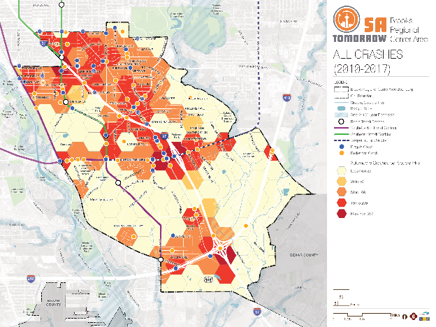
Continue Implementing the San Antonio Vision Zero Action Plan.The City of San Antonio’s Vision Zero initiative aims to achieve zero fatalities on the community’s roadways and improve roadway safety for all users, whether driving, bicycling, or walking. The Vision Zero initiative evaluates and makes recommendations to improve safety in Severe Pedestrian Injury Areas (SPIAs), locations where two or more crashes close together have resulted in severe pedestrian injuries. Potential tools for improving pedestrian safety in Severe Pedestrian Injury Areas include Leading Pedestrian Intervals, Medians, and Pedestrian Crossing Islands based upon analysis of the unique factors that contribute to crashes in each location and depending upon the results of engineering assessments. Another approach to improve safety involves dedicating more space in the roadway to bicyclists and pedestrians. From new ways to protect bicycle lanes with separated barriers such as bollards, to landscaping and planters and raised medians, San Antonio has many available tools to improve pedestrian and bicycle safety. The City of San Antonio Vision Zero Action Plan lists additional tools for improving pedestrian and bicycle safety.
The Brooks Area has a wealth of opportunities for improving mobility and safety, especially for pedestrians. In particular, the 2018 San Antonio Severe Pedestrian Injury Areas Report1 (pages 29-30) identifies three Severe Pedestrian Injury Areas (SPIAs) within or adjacent to the Brooks Area Regional Center that should be priorities for study and investment:
Additional analysis of pedestrian, bicycle, and vehicle crash data, along with community input, also identified as priorities the following:
Investments that focus on safety, such as the Vision Zero tools listed above, can have a significant positive impact throughout the Brooks Area, and especially in these identified conflict areas.
Access Management
For all people to travel safely while walking, bicycling, or driving in the study area, points of conflict between people and vehicles must be minimized. Currently, there are many points of conflict, for example, many driveways (aka ‘curb cuts’) along roadways including SE Military Drive and Goliad Road. These spaces are used by all people traveling and can be difficult to navigate for bicyclists, pedestrians, and people with disabilities. Employing strategies to reduce these points of conflict can increase safety in the study area.
Recommendation #2:
Complete the multimodal layered network and trail system and work with partners to establish new connections.Complete Streets
A network of complete streets is envisioned for the Brooks Area, providing enhanced road designs for vehicles, pedestrians, and cyclists alike. Presa Street, Hot Wells Boulevard, Kashmuir Place, Goliad Road, and SE Military Drive are recommended for the Transportation and Capital Improvements Department to study for complete streets improvements, coordinating with TxDOT, VIA, and ongoing Bond projects as needed. These streets will help connect residents to recreational trails, such as the new Greenline and Mission Reach Trails, allowing Brooks Area residents to enjoy longer trips and recreation beyond the sub-area.
Priority Streetscape Improvements
The Brooks Area community envisions Presa Street as a pedestrian greenway ‒ a park-like corridor, complete with landscaping, green infrastructure, and other placemaking features. This could entail a number of unique elements such as public art, picnic tables, or exercise stations. Work is ongoing with TCI to design and implement this 2017 Bond project. Streetscape improvements are also recommended for study on other corridors. These include roads that primarily serve local residents, such as Goliad Road and Hot Wells Boulevard, as well as major roads for through traffic, such as SE Military Drive. The vision for SE Military is one where people feel welcome, safe, and comfortable, whether walking, biking, taking transit, or driving. It is highly recommended that TCI work with TxDOT and other partners to reimagine SE Military as a place where people want to go, rather than just pass through.
Priority Trails
In 2016, construction began on the Greenline, a new 43-acre linear park at Brooks, and was completed in 2018. This park includes a hike and bike trail which will ultimately connect to regional recreational resources like the Mission Reach Trail on the San Antonio River. Additionally, partnerships with local utility providers are exploring opportunities to secure additional right-of-way along designated utility easements. These areas could expand the space dedicated to a planned trail network in the Brooks Area. The plan also envisions an expanded on-street network that will also connect the Brooks Area to recreational bicycle/pedestrian trails to the west (along the San Antonio River) and the east (along Salado Creek).
Preferred Bicycle Routes
In many parts of the Brooks Area, bicyclists currently ride adjacent to mixed-traffic on high-stress roads. Additional bike infrastructure, such as designated lanes, is highly recommended. These measures will improve riding conditions for today’s commuters and welcome newer, less confident bicyclists, otherwise unaccustomed to riding alongside vehicles. Based on input from the Brooks Area Regional Center Planning Team and other community stakeholders, the plan identifies Pecan Valley Drive, Asylum Creek, Corpus Christi Highway, streets throughout the Brooks campus, and Presa Street as priority bicycling routes for the Brooks Area. Southeast Military Drive, Hot Wells Boulevard, and Goliad Road should also incorporate cycling infrastructure as a component of designs for complete streets based on future studies by TCI to determine feasibility and the types of facility needed.
Recommendation #3:
Alleviate congestion with multimodal options.Shifting users from driving alone to alternative modes of transportation can alleviate congestion along a corridor or within an area. This becomes more viable when alternatives are convenient, such as through improved access to transit and pedestrian-friendly infrastructure. This strategy directly supports the community's, City’s, and VIA’s goals and objectives, improving access to key destinations, decreasing vehicle miles traveled, and increasing the area’s walkability. To support growth and continue the vibrancy of the region’s economic centers, the community needs easy, reliable, and congestion‑proof choices for traveling to and from work, school, and key destinations.
While congestion can be viewed as a sign of economic health, delays caused by congestion waste valuable time and create transportation emissions that reduce air quality. The transportation industry has learned ‘we cannot build our way out of congestion’, however a series of operational and multimodal improvements can provide more travel options and reduce the demand on our roadways. Several hotspots have been identified through the planning process that should receive further attention and study by TCI to mitigate congestion. With I-37 and Loop 410 within the study area, residual interstate congestion blends with local congestion. Area analysis identified corridors such as South New Braunfels Avenue and South Gevers Street and intersections such as Goliad Road and SE Military Drive, Goliad Road & Pecan Valley Drive, and Goliad Road & South Gevers Street as key congested areas with need for study and improvement.
VIA’s Rapid Transit Corridors will create additional transportation choices in this area with new investments in very frequent transit service that quickly moves people to their destinations. This additional transit service on the Southeast side will provide more direct connections between the Brooks Area, Near Westside neighborhoods, and Pearl.
Recommendation #4:
Consider freight movements and needs in land use and transportation planning activities.Freight trucks deliver many of the items needed for day-to-day life but are often overlooked in planning for our communities. Freight delivery has been changing rapidly as more people buy products online that are delivered to homes by small freight trucks. As redevelopment of roads and parcels takes place, the needs for freight to be able to serve our communities will need to be considered and space should be dedicated for light and heavy freight trucks to travel, turn, and park.
Recommendation #5:
When VIA Rapid Transit Corridor service is implemented in the Brooks Area, prioritize improvements that provide safe connections to the transit line for people walking, bicycling, or getting dropped off in a vehicle.Every person that rides transit is also a pedestrian. As of spring 2018, VIA is actively enhancing its Primo service along SE Military, and another key rapid transit route under consideration includes service along New Braunfels Avenue throughout the study area. As VIA expands these and other transit options in the Brooks Area, these services should be easily accessed by people walking and bicycling to transit stations and stops. Critical components of VIA’s approach to making a place transit-supportive are streets designed for pedestrians, improving the safety of all users, and supporting compact, mixed-use development providing access to a variety of services reachable on foot. Investing in complete streets along transit corridors as well as streets that lead to these corridors will improve the overall transit experience, increase safety, and encourage walking, bicycling, and taking transit as mobility options in the Brooks Area.
Many of the concepts and strategies in Mobility Recommendation #2 can also contribute to safe transit connections.
In addition to these planned transit investments, Presa Street is envisioned as a pedestrian greenway – a street that offers the shade of trees and a park-like atmosphere, providing safe access to VIA local bus service and nearby rapid transit service expected on New Braunfels Avenue.
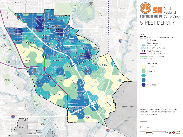
Street configuration directly impacts an area’s last-mile connectivity to and from transit stations. Places with dense streets and shorter blocks, such as downtowns, provide more direct routes to destinations and more storefront access. The map shown below provides a visual evaluation of block density in the Brooks Area. Places that are most accommodating to transit, bicycles, and pedestrians, have a tight grid network (indicated by darker shades of blue), meaning people can experience fairly direct access to their destination. Areas with low block density (such as is evident in the lighter shades shown in the southern half of the study area) are often caused by large campuses or industrial sites. Brooks Development Authority has a vision of working with partners to create new east-west connections that will help increase block density and a more complete grid street network throughout the campus.
Mobility was discussed at Planning Team #3 as part of drafting the plan framework. A variety of transportation options were considered when planning for the Brooks Area. Trails, transit routes, bicycle routes, streetscape improvements, pedestrian safety, and traffic congestion were discussed in order to create a layered multimodal transportation network.
At Community Meeting #2, participants were asked to complete two activities to help City staff prioritize different routes for different types of transit, and to see what type of street features are desired by the community.
Major corridors were identified on the mobility framework diagram. Participants then voted using stickers with bus, car, and bicycle icons to symbolize what mode of travel they thought needed to be prioritized on each street. The other activity featured two major thoroughfares in the area. Participants then chose elements such as bike lanes, turn lanes, and medians to design streets for their preferred modes of transportation.
Mobility Concepts
The recommendations in this plan will help create a user-friendly multimodal network that provides access to amenities, links Brooks Area residents and employees to the greater San Antonio Area, and supports planned activity centers and land uses. The general concepts below serve as guiding principles for the more detailed Mobility Recommendations listed above, and several are illustrated for the Brooks Area on the Mobility Framework Map.
Complete Streets
In September 2011, San Antonio adopted a Complete Streets Policy (Ordinance 2011-09-29-0795) which encourages street designs that take into account all users and accommodate all ages and abilities including children, older adults, and persons with disabilities.
This approach to street design “supports pedestrian and bicycle-oriented neighborhoods; promotes healthy living, fitness, and activity; enhances the economic vitality of commercial corridors and districts; and maximizes the benefits of investment in public infrastructure.”[2] Not all “complete” streets have to be the same; the function of the road, level of traffic by mode, and adjacent land use and intensity will all be used to help determine road type and design features.
Priority Bicycle Routes and Streetscape Improvements
Creating a Regional Center that encourages walking and biking as convenient, safe, and comfortable options will require an integrated network of pedestrian and bicycle routes along with well-designed streets in key activity areas. Today, there are gaps in the multimodal system serving the Brooks Area, especially for people wishing to walk or bike. This plan focuses on completing sidewalk and bicycle networks and recommends new connections that will help people travel east-west in the study area, and more directly access creeks, trails, and other amenities.
Coordinated Land Use and Transportation Plans
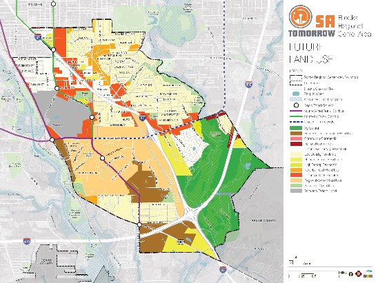
The figure above shows the draft land use plan for Brooks. As land uses evolve and new developments are added to the Brooks Area, the demand for transportation will also change. Planned land uses are likely to increase density along S. New Braunfels Avenue in the blocks from Koehler Court to Stratford Court; along Goliad Road from Southcross to I-410; along the length of SE Military in the study area; and within Brooks.With additional density in land use, the major roadways can anticipate additional people pedestrians, bicyclists, transit riders, single automotive vehicles and freight delivery trucks of various sizes. In the future, more density in the area will mean more demand for pedestrian and bicycle facilities and VIA transit service.
Improved Pedestrian Crossing
Safety is central to planning for the Brooks Area’s development as a walkable center. Analysis of previous pedestrian crashes has identified intersections and roads most in-need of study for additional pedestrian crossings or other safety improvements. Improved access to VIA service is also a key factor guiding pedestrian safety studies and investments.
Frequent, Reliable, and Accessible Transit
VIA’s ongoing planning efforts are working to identify new Primo and Rapid Transit corridors. Detailed studies are looking at exact routing and phasing of construction for these improved transit routes that will provide more options for people to get around both within the Brooks Area as well as to other employment, education, and activity centers across the city. Complete streets and place making investments near planned stations are important to improve people’s ability to access transit using safe and pleasant community connections.
Linked Mobility and Land Use
As communities evolve and grow, so do the demands on the mobility system. The location and type of growth in an area or along a corridor help determine the demand on the transportation network and viability of various transportation options. Likewise, transportation helps shapes the desirability and type of development in an area. Aligning this relationship shapes future development and growth patterns and directly supports the community’s goals and objectives of improving walkability, increasing access to transit, and enhancing access to economic areas and other key destinations. Such alignment of land use and mobility also helps implement VIA’s 2040 Strategic Plan for Station Areas, supporting transit-supportive land use surrounding transit stations.
As the Brooks Area Regional Center adds residents and employees based on the community’s updated land use plan and proposed focus areas, impacts on the mobility needs of these new people and those of the current residents need to be considered. For example, if several multi-story residential and office buildings are added along Goliad Road, additional pedestrian, bicycle, and vehicle traffic can be expected on the streets and new mobility patterns will emerge. Studies will need to determine common paths and volumes of pedestrian, bicycle, automobile, transit, and freight travel to ensure the area has sufficient infrastructure and careful prioritization of modes to help people safely reach their destinations.
Mixed-use and higher density developments in identified focus areas and along key corridors will require integrated mobility planning to ensure people can access, use, and pass through these areas safely and comfortably by all modes of travel. In particular, changing land uses and mobility needs are anticipated along South New Braunfels Avenue, in the blocks from Koehler Court to Stratford Court, along the length of Goliad Road from Southcross Boulevard to Loop 410, along the length of Southeast Military Drive in the study area, and in the Brooks campus. With additional density in land use, the major roadways can anticipate additional pedestrians, bicyclists, transit riders, single automobile vehicles, and freight delivery trucks of various sizes. In the future, more density in the area will mean more demand for pedestrian and bicycle facilities and VIA transit service.
Gateway Opportunities
To build on the strong community identity of San Antonio’s Southside and the Brooks Area, several places within this sub-area provide opportunities for unique neighborhood gateways. Gateways display pride in a local area and welcome residents and visitors with art and architectural elements which reflect neighborhood history and culture. There are numerous places for gateways on Presa Street, notably at Hot Wells Boulevard and Southeast Military Drive. These gateways along South Presa Street would help create a cohesive, connected, and walkable corridor. On the eastern side of the sub-area, the intersection of Goliad Road and Southeast Military Drive could also serve as a notable gateway to the Brooks Area.