Plan Framework
Focus Areas
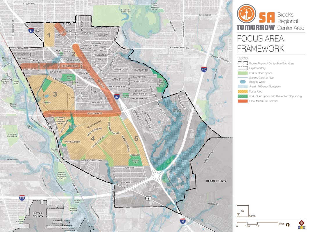
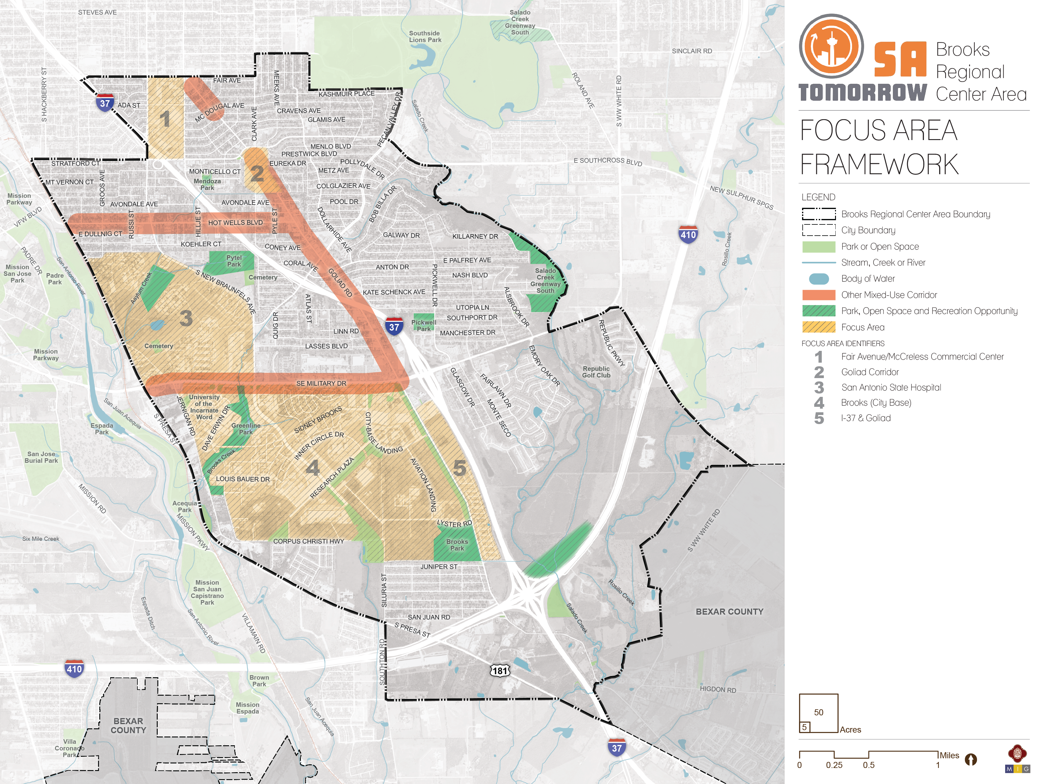
The map below highlights the Focus Areas identified for the Brooks Regional Center Area. To learn more about each of the five focus areas, click on the animated targeted circle.
You can also visit the bottom of the page to leave additional feedback.
Recommendation #1:
Create mixed-use community destinations that increase residential, employment, and recreational opportunities throughout the Brooks Area Regional Center.- The Brooks community is highly supportive of creating destinations in their community that bring people together, offer additional dining and entertainment options, and increase recreational opportunities.
- Creating additional mixed-use communities in the focus areas will help bring jobs to Brooks Area residents and allow some workers to live closer to their places of employment.
Recommendation #2:
Ensure focus areas can be easily and safely accessed by a range of travel modes, including pedestrian, bicycle, and transit options.- Current development and mobility patterns in the Brooks Area favor the automobile, although many residents rely on walking, biking, and transit for their day-to-day needs.
- Multimodal transportation improvements will allow more Brooks Area residents to safely and easily access new amenities and services without relying on a vehicle.
Recommendation #3:
Ensure adequate buffers and transitions between new, higher-intensity development in focus areas and single-family neighborhoods.- Protect established, low-density single-family residential neighborhoods from potential unwanted impacts of new, more intense development.
Recommendation #4:
Balance development and investment in focus areas with protection and enhancements of open spaces, including parks, natural resources, and other sensitive areas.- A key goal of the Brooks Area Regional Center planning process was to protect and enhance undeveloped green spaces and natural areas even as growth and development occur.
- Open spaces should be created, preserved or strengthened within and between focus areas.
At Planning Team Meeting #3 held on September 13th, 2017, the Planning Team completed an exercise to identify areas within the Brooks Area that they would like to see improvements, additional parks, plazas, corridors, and streetscape improvements among other items. These elements were drawn on trace paper over transportation and amenity maps. The Planning Team members worked in small groups to complete and present these maps.
The Planning Team identified multiple areas and streets in need of improvements. These were then mapped on the plan framework diagram.
At Planning Team #4 on October 26th, 2017, the Planning Team further refined the focus areas. For the selected focus areas, the Planning Team identified purpose, future character, appropriate building heights, and areas of transition. This exercise was also completed at Community Meeting #2 on November 18th, 2017.
Focus Area #1: Fair Avenue/McCreless Commercial Center
The vision for the Fair Avenue/McCreless Commercial Center is to build on the success of this commercial destination to bring additional dining, entertainment and retail options to local residents alongside community amenities and services. Residential units should be incorporated in mixed-use development, particularly where the Focus Area borders existing single-family neighborhoods.
The Fair Avenue/McCreless Commercial Center focus area will be intensified through development and redevelopment that "infills" parking lots and other under-utilized spaces. Buildings will range from two to four stories and will be oriented towards adjacent streets with parking on the interior of the site and/or behind buildings whenever possible. Streetscape and mobility improvements will allow residents to more easily and safely access this area without a vehicle. Additional landscaping and greenways will “soften” the feeling of this focus area and fewer parking lots will create opportunities for improved stormwater treatment.
Focus Area #2: Goliad Corridor
The vision for Goliad Road north of SE Military is for a mixed-use corridor that is human-scaled, pedestrian-friendly, comfortable, safe, and visually pleasing. Land uses along the road will include single-family residential in the Highland Hills neighborhood with a mix of single- and multi-family residential and a diverse range of commercial uses south of Southcross.
Buildings will range from one to four stories, with height greatest at key nodes and major intersections. Height will step down to provide transitions to lower-density areas including single-family residential. Buildings will be oriented to the street, generally with parking behind them. The corridor will have a vibrant streetscape that allows safe and comfortable pedestrian mobility and access to businesses, offices, and other destinations. It will include traffic-calming measures as well as street trees, lighting, crosswalks, and other infrastructure to create a pleasant pedestrian-scaled environment. Small parks and plazas will create gathering places for residents and visitors and soften the urban environment.
Focus Area #3: San Antonio State Hospital
The vision for the SASH site is for a mix of protected open space and parks alongside institutional, commercial and residential uses. The hospital itself is slated for redevelopment and will continue to operate indefinitely, but with a smaller footprint. New uses will preserve an adequate buffer around the hospital itself to ensure privacy and safety for patients and other residents.
The site will include both passive and active recreation sites, including protected areas adjacent to State Hospital (Asylum) Creek and the pond. A park may be created that can serve as a bird and butterfly sanctuary or other low-impact recreation use that protects natural resources and habitat. Heritage pecan trees will be preserved and protected.
The area parallel to the creek will be re-envisioned as a trail or greenway that enhances bicycle and pedestrian mobility through the site as well as connections to the Mission Reach of the San Antonio River Trail. Trail-oriented development will showcase the creek as a unique natural feature while protecting it with development setbacks. Mixed-use sites will provide a mix of housing types, including mid-density products such as attached townhomes and clustered cottages that provide opportunities for moderate-income households, including first-time homebuyers. Commercial and civic uses will front Asylum Creek as well as South Presa Street and South New Braunfels Avenue. Opportunities for improved internal circulation and east-west mobility will be maximized.
Focus Area #4: Brooks (City Base)
The vision for Brooks is a dynamic, mixed-use community that provides multiple opportunities for living, working, learning, and playing within its borders. The area’s history will be celebrated through preservation, interpretation through multiples lenses, and by a growing cluster of dynamic, innovative businesses and institutions. A town center will serve as “downtown Brooks,” providing urban gathering places, entertainment destinations, and residences.
A diversity of housing types will offer both rental and ownership opportunities in multi- and single-family developments that are accessible to a range of income levels. New sidewalks, bikeways and trails, including the new 43-acre Greenline linear park, will improve options for non-motorized transportation and support a healthy outdoor lifestyle. The area will be well-served through the Brooks Transit Center which takes advantage of its proximity to downtown San Antonio and other urban centers. Residents will be able to easily access the San Antonio River.
Brooks will be an economic development powerhouse, with hundreds of high-paying jobs supporting Southside residents and families. The area’s history of innovation will be continued through medical, technological, and educational endeavors within its borders.
Focus Area #5: I-37 and Goliad
The vision for the I-37 & Goliad Focus Area is a mixed-use center that includes a more intense concentration of regional-serving commercial uses near the intersection of I-37 that are easily accessible by automobile. Mid-density, 2 to 3-story buildings will include a mix of commercial businesses to the north, transitioning to primarily residential to the south.
The edge of the focus area along Goliad Road will provide a greenway that facilitates recreation and mobility. Improved east-west mobility options will allow residents to easily access nearby amenities, including Salado Creek and the adjacent green spaces and the Brooks campus.