Plan Framework
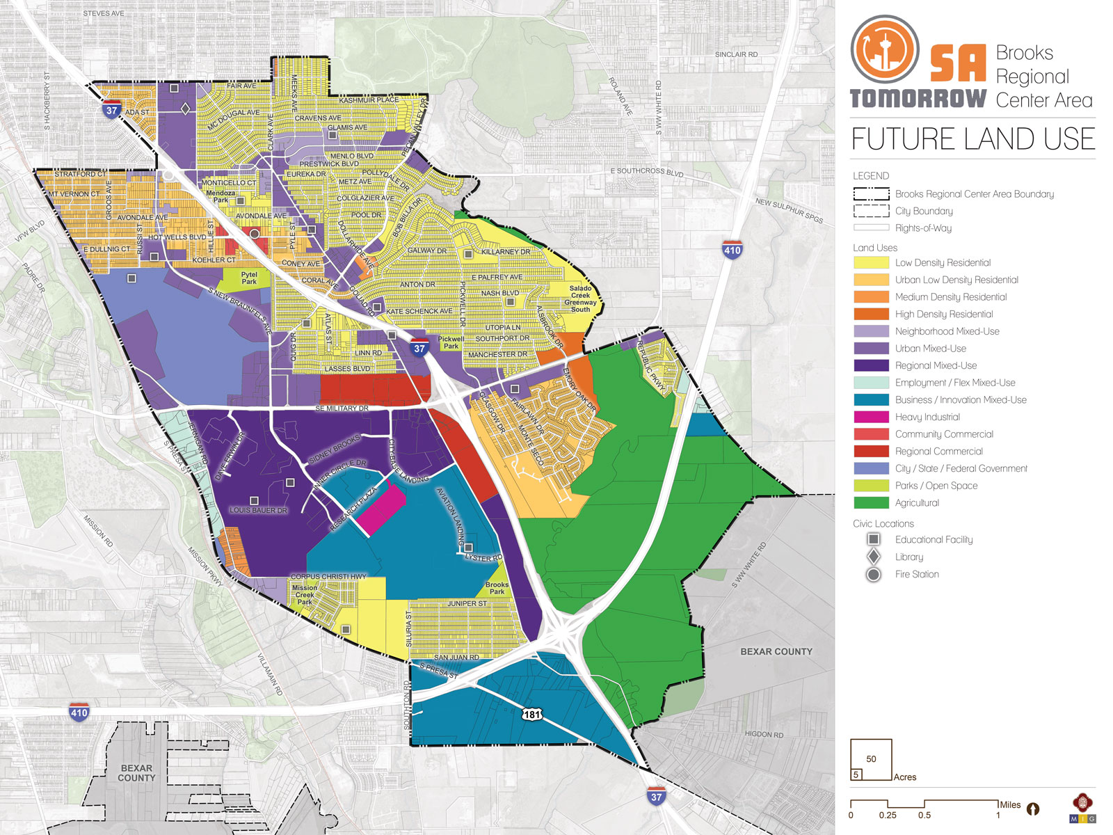
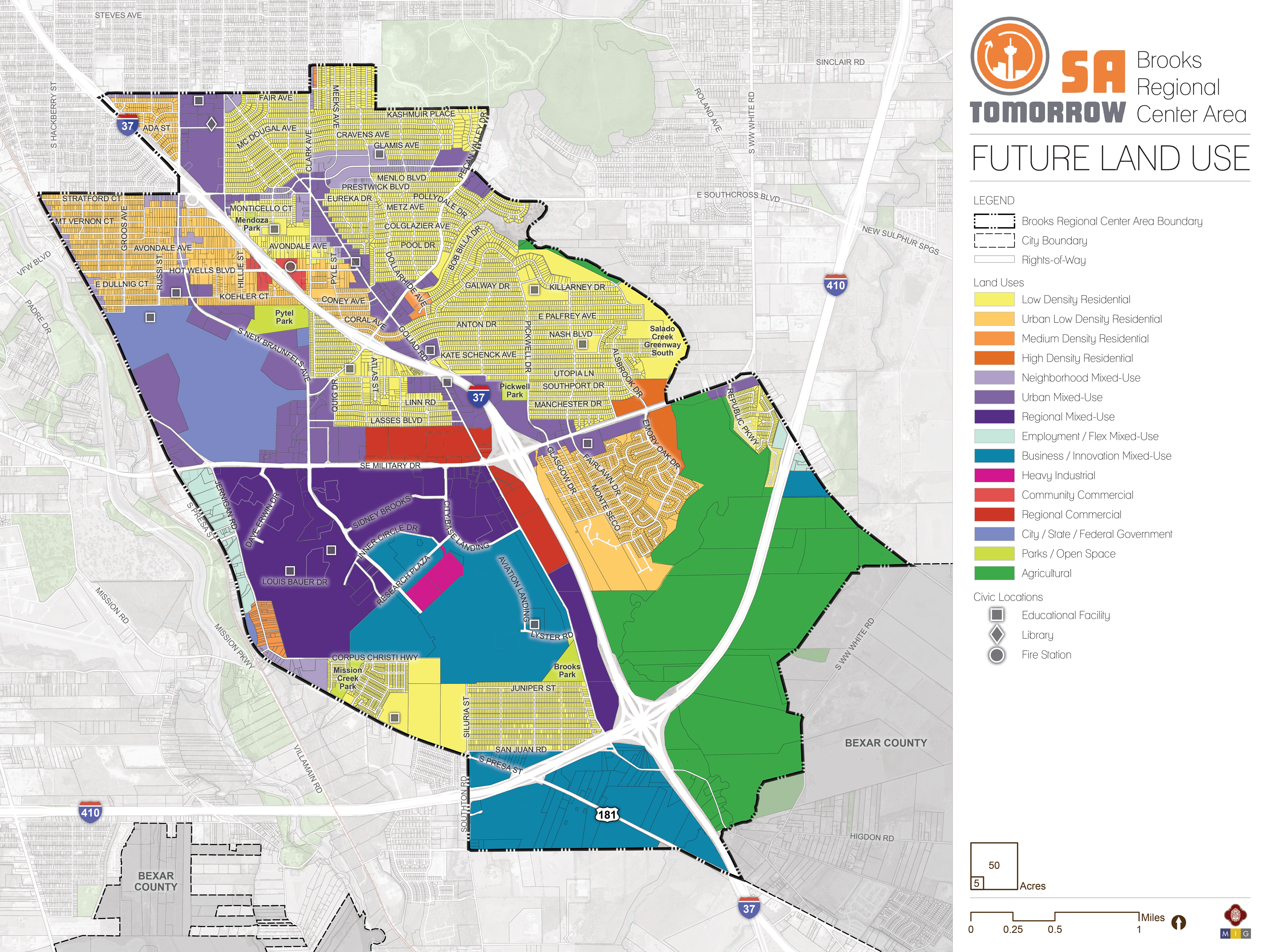
Land Use
Recommendation #1:
Prioritize City-initiated rezoning for single-family residential areas that are currently over zoned.Recommendation #2:
Use City-initiated large area rezoning in mixed-use focus areas and corridors to support implementation of designated new land uses, support catalytic development, and encourage transit-supportive development near future VIA stations.Recommendation #3:
Evaluate, and update as needed, zoning and development regulations that impede implementation of Brooks Area Regional Center Plan land uses and desired urban form.Future Land Use Categories
As described above, the Brooks Area Regional Center Plan includes a range of land use designations that represent the unique character of the area, while encouraging and supporting development patterns that reflect the goals of the SA Tomorrow Comprehensive Plan and the preferences of the Brooks Area Regional Center community. Listed below is the full list of land use categories adopted by City Council into the Unified Development Code (UDC), Chapter 35, on October 11, 2018. Each category listed includes a description, general guidance on where the land use designation is most appropriate, and a list of allowable zoning districts.
Residential Estate
Residential Estate includes large lot single-family detached houses on individual estate-sized lots or in conservation subdivisions. This form of development should be located away from major arterials, and can include certain nonresidential uses such as schools, places of worship, and parks that are centrally located for convenient neighborhood access. Permitted zoning districts: FR, R-20, RE, and RP.
Typical densities in this land use category would be up to 2 dwelling units per acre.
Low Density Residential
Low Density Residential includes single-family detached houses on individual lots, including manufactured and modular homes. This form of development should not typically be located adjacent to major arterials. This land use category can include certain nonresidential uses such as schools, places of worship, and parks that are centrally located for convenient neighborhood access. Permitted zoning districts: R-4, R-5, R-6, NP-8, NP-10, and NP-15.
Typical densities in this land use category would range from 3 to 12 dwelling units per acre.
IDZ and PUD may be considered consistent with this land use category, provided the permitted uses included on the zoning site plan and zoning ordinance are consistent with the uses and densities outlined above.
Urban Low Density Residential
Urban Low Density Residential includes a range of housing types including single-family attached and detached houses on individual lots, small lot residences, duplexes, triplexes, fourplexes, cottage homes, manufactured homes, low-rise garden- style apartments, and manufactured home parks. This land use category may also accommodate small scale retail and service uses that are intended to support the adjacent residential uses. Other nonresidential uses, including, but not limited to, schools, places of worship, and parks are appropriate within these areas and should be centrally located to provide easy accessibility. Permitted zoning districts: R-3, R-4, R-5, R-6, RM-5, RM-6, MF-18, MH, MHC, MHP, and NC.
Typical densities in this land use category would range from 7 to 18 dwelling units per acre.
IDZ, PUD, MXD, and TOD may be considered consistent with this land use category, provided the permitted uses included on the zoning site plan and zoning ordinance are consistent with the uses and densities outlined above.
Medium Density Residential
Medium Density Residential accommodates a range of housing types including single-family attached and detached houses on individual lots, manufactured and modular homes, duplexes, triplexes, fourplexes, and low-rise, garden-style apartments with more than four (4) dwelling units per building. Cottage homes and very small lot single-family houses are also appropriate within this land use category. Higher density multi-family uses, where practical, should be located in proximity to transit facilities. Certain nonresidential uses, including, but not limited to, schools, places of worship, and parks are appropriate within these areas and should be centrally located to provide easy accessibility. Permitted zoning districts: R-3, R-4, RM-4, RM-5, RM-6, MF-18, MF-25, MF-33, MH, MHC, and MHP.
Typical densities in this land use category would range from 13 to 33 dwelling units per acre.
IDZ, PUD, MXD, and TOD may be considered consistent with this land use category, provided the permitted uses included on the zoning site plan and zoning ordinance are consistent with the uses and densities outlined above.
High Density Residential
High Density Residential includes low-rise to mid-rise buildings with four (4) or more dwelling units in each. High density residential provides for compact development including apartments, condominiums, and assisted living facilities. This form of development is typically located along or near major arterials or collectors. High density multi-family uses should be located in close proximity to transit facilities. Certain nonresidential uses, including, but not limited to schools, places of worship, and parks are appropriate within these areas and should be centrally located to provide easy accessibility. This classification may be used as a transitional buffer between lower density residential uses and nonresidential uses. High density residential uses should be located in a manner that does not route traffic through lower-density residential uses. Permitted zoning districts: RM-4, MF-25, MF-33, MF-40, MF-50, MF-65, MH, MHC, and MHP.
Typical densities in this land use category would range from 25 to 50 dwelling units per acre.
IDZ, PUD, MXD, and TOD may be considered consistent with this land use category, provided the permitted uses included on the zoning site plan and zoning ordinance are consistent with the uses and densities outlined above.
Neighborhood Commercial
Neighborhood Commercial includes smaller intensity commercial uses such as small-scale retail or offices, professional services, and convenience retail and services that are intended to support the adjacent residential uses. Neighborhood commercial uses should be located within walking distance of neighborhood residential areas. Special consideration should be given to pedestrian and bicycle facilities that connect neighborhoods to commercial nodes. Permitted zoning districts: O-1, NC, and C-1.
IDZ, PUD, MXD, TOD, and MPCD may be considered consistent with this land use category, provided the permitted uses included on the zoning site plan and zoning ordinance are consistent with the uses and densities outlined above.
Community Commercial
Community Commercial includes offices, professional services, and retail uses that are accessible to bicyclists and pedestrians and linked to transit facilities. This form of development should be located in proximity to major intersections or where an existing commercial area has been established. Community commercial uses are intended to support multiple neighborhoods, have a larger market draw than neighborhood commercial uses, and attract patrons from the neighboring residential areas. All off-street parking and loading areas adjacent to residential uses should include landscape buffers, lighting, and signage controls. Examples of community commercial uses include, but are not limited to, cafes, offices, restaurants, beauty parlors, neighborhood groceries or markets, shoe repair shops and medical clinics. Permitted zoning districts: O-1.5, NC, C-1, and C-2.
IDZ, PUD, MXD, TOD, and MPCD may be considered consistent with this land use category, provided the permitted uses included on the zoning site plan and zoning ordinance are consistent with the uses and densities outlined above.
Regional Commercial
Regional Commercial includes high intensity uses that draw customers from both adjacent communities as well as the larger metropolitan region. Regional commercial uses are typically located in general proximity to nodes along expressways or major arterial roadways and incorporate high-capacity transit facilities. Regional Commercial uses should incorporate well-defined entrances, shared internal circulation, limited curb cuts to expressways and arterial streets, sidewalks and shade trees in parking lots, landscaping between the parking lots and roadways, and well- designed monument signage. Examples of regional commercial uses include, but are not limited to, movie theaters, plant nurseries, automotive repair shops, fitness centers, home improvement centers, hotels and motels, mid- to high-rise office buildings, and automobile dealerships. Permitted zoning districts: O-1.5, O-2, C- 2, C-3, L, and BP.
IDZ, PUD, MXD, TOD, and MPCD may be considered consistent with this land use category, provided the permitted uses included on the zoning site plan and zoning ordinance are consistent with the uses and densities outlined above.
Neighborhood Mixed-Use
Neighborhood Mixed-Use contains a mix of residential, commercial, and institutional uses at a neighborhood scale. Within mixed-use buildings, residential units located above first floor are encouraged. Typical first floor uses include, but are not limited to, small office spaces, professional services, and small scale retail establishments and restaurants. The mix of uses may be vertically or horizontally distributed, and there is no requirement that a single building contain more than one use. Live/work housing options are permissible in Neighborhood Mixed-Use area to ensure access to housing options and services within close proximity for the local workforce. Where practical, buildings are situated close to the public right-of-way, and parking is located behind buildings. Parking requirements may be minimized using a variety of creative methods, such as shared or cooperative parking agreements, to maximize land available for housing and community services. Pedestrian spaces are encouraged to include lighting and signage, and streetscaping should be scaled for pedestrians, cyclists, and vehicles. Properties classified as Neighborhood Mixed-Use should be located in close proximity to transit facilities. Permitted zoning districts: RM-4, RM-5, RM-6, MF-18, O-1, NC, C-1, MH, MHC, MHP, FBZD, AE-1, and AE-2.
IDZ, PUD, MXD, TOD, and MPCD may be considered consistent with this land use category, provided the permitted uses included on the zoning site plan and zoning ordinance are consistent with the uses and densities outlined above.
Urban Mixed-Use
Urban Mixed-Use contains a mix of residential, commercial, and institutional uses at a medium level of intensity. Urban Mixed-Use development is typically larger-scale than Neighborhood Mixed-Use and smaller-scale than Regional Mixed-Use, although many of the allowable uses could be the same in all three categories. Building footprints may be block-scale, but could be smaller depending on block configuration and overall development density. Typical first floor uses include, but are not limited to, professional services, offices, institutional uses, restaurants, and retail including grocery stores. The mix of uses may be vertically or horizontally distributed, and there is no requirement that a single building contain more than one use. Live/work housing options are permissible in Urban Mixed-Use areas to ensure access to housing options and services within close proximity for the local workforce. Structured parking is encouraged in Urban Mixed-Use category, but is not required. Parking requirements may be satisfied through shared or cooperative parking agreements, which could include off-site garages or lots. The Urban Mixed-Use category should be located in proximity to transit facilities. Permitted zoning districts: RM-4, RM-5, RM-6, MF-18, MF-25, MF-33, MF-40, O-1, O-1.5, C-1, C-2, MH, MHP, MHC, FBZD, AE-1, AE-2, AE-3, and AE-4.
IDZ, PUD, MXD, TOD, and MPCD may be considered consistent with this land use category, provided the permitted uses included on the zoning site plan and zoning ordinance are consistent with the uses and densities outlined above.
Regional Mixed-Use
Regional Mixed-Use contains residential, commercial, and institutional uses at high densities. Regional Mixed-Use developments are typically located within regional centers and in close proximity to transit facilities, where mid-rise to high-rise buildings would be appropriate. Typical lower floor uses include, but are not limited to, offices, professional services, institutional uses, restaurants, and retail including grocery stores. The mix of uses may be vertically or horizontally distributed, and there is no requirement that a single building contain more than one use. Live/work housing options are permissible in Regional Mixed-Use areas to ensure access to housing options and services within close proximity for the local workforce. Where feasible, development is ideally built at the block scale, with minimum building setbacks. Parking requirements may be satisfied through shared or cooperative parking agreements, which can include off-site garages or lots. If parking requirements are satisfied on-site, structured parking is encouraged. Pedestrian spaces are encouraged to be generous in width and lighting, with streetscaping and signage scaled to pedestrians. Regional Mixed-Use projects encourage incorporation of transit facilities into development. Permitted zoning districts: MF-33, MF-40, MF-50, MF-65, O-1.5, O-2, C-2, C-3, D, ED, FBZD, AE-1, AE-2, AE-3, and AE-4.
IDZ, PUD, MXD, TOD, and MPCD may be considered consistent with this land use category, provided the permitted uses included on the zoning site plan and zoning ordinance are consistent with the uses and densities outlined above.
Employment/Flex Mixed-Use
Employment/Flex Mixed-Use provides a flexible live/work environment with an urban mix of residential and light service industrial uses. Uses include smaller-scale office, retail, art studio warehouses, art-oriented fabrication, creative businesses and work spaces, and cottage industrial and fabrication uses. Adaptive uses of vacant or underutilized structures are encouraged to provide residential urban infill and appropriate employment opportunities within or in close proximity to neighborhoods. Buildings have a smaller footprint and can closely resemble campus-like development across multiple sites or with several multi-functioning buildings on one site. Permitted zoning districts: RM-4, MF-18, MF-25, MF-33, O-1, O-1.5, C-1, C-2, L, AE-1, AE-2, AE-3, and AE-4.
IDZ, PUD, MXD, TOD, and MPCD may be considered consistent with this land use category, provided the permitted uses included on the zoning site plan and zoning ordinance are consistent with the uses and densities outlined above.
Business/Innovation Mixed-Use
Business/Innovation Mixed-Use accommodates industrial uses with office, commercial, and residential uses, all within a cohesive setting, on a larger scale and within larger footprints than the Employment/Flex Mixed-Use category. Industrial arts workshops, high tech fabrication, processing and assembly, and other industrial uses are permitted, in addition to commercial uses. Vocational training, technological learning centers, medical campuses, and research/development institutions are also appropriate for these spaces. Additional environmental performance standards should be employed for properties designated as Business/Innovation Mixed-Use, such as hours of activity, loading, noise levels, and lighting, to ensure that the intensity of the industrially oriented uses is comparable to that of the other non-residential uses. The mix of uses may be either vertically or horizontally distributed. Live/work housing options are permissible in Business/Innovation Mixed-Use areas to ensure access to housing options and services within close proximity of business innovation areas for the local-workforce. Business/Innovation Mixed-Use should incorporate transit and bicycle facilities to serve the training and employment base. Permitted zoning districts: RM-4, MF-18, MF-25, O-1.5, O-2, C-2, C-3, L, I-1, MI-1, BP, AE-1, AE-2, AE-3, and AE-4.
IDZ, PUD, MXD, TOD, and MPCD may be considered consistent with this land use category, provided the permitted uses included on the zoning site plan and zoning ordinance are consistent with the uses and densities outlined above.
Light Industrial
Light Industrial includes a mix of manufacturing uses, business park, and limited retail/service uses that serve the industrial uses. Industrial uses should be screened and buffered from adjoining non-industrial uses. Any outside storage should be under a roof and screened from public view. Examples of light industrial uses include drug laboratories, furniture wholesalers, lumberyards, food production, and warehousing. Permitted zoning districts: L, I-1, MI-1, and BP.
IDZ, TOD, and MPCD may be considered consistent with this land use category, provided the permitted uses included on the zoning site plan and zoning ordinance are consistent with the uses and densities outlined above.
Heavy Industrial
Heavy Industrial includes heavy manufacturing, processing, and fabricating businesses. Heavy industrial uses shall be concentrated at arterials, expressways, and railroad lines. This category is not compatible with neighborhood-scaled categories or those that permit residential zoning. Heavy Industrial should be separated from non-industrial uses by an allowable land use or a significant buffer. Examples of heavy industrial uses include auto manufacturing, battery manufacturing, and petro chemical bulk storage. Permitted zoning districts: I-1, I-2, MI-1, MI-2, QD, and SGD.
Agricultural
Agricultural includes crop agriculture, ranching, and related agribusiness practices. Single-family detached houses and detached accessory dwelling units are permitted on agricultural and ranch lands at very low densities or in conservation subdivisions that will not interfere with agricultural operations. Limited commercial uses directly serving agricultural and ranching uses, such as farmers markets, nurseries, stables, bed and breakfasts are permitted. To maintain scenic qualities, natural vegetative buffers, deeper setbacks, increased signage control, earthen drainage channels, and more restrictive access management standards are desired along major scenic corridors. Floodplain protection and buffer zones along creeks and rivers are instrumental in retaining rural character. Permitted zoning districts: RP and FR.
Parks/Open Space
Parks/Open Space may include, but is not limited to, large, linear, or unimproved land where conservation is promoted, and development is not encouraged due to the presence of topographic constraints or institutional uses on the site. Parks/Open Space may include utility corridors and public or private land uses that encourage outdoor passive or active recreation. Examples include city owned and/or operated pocket, regional, or linear parks, as well as private parks associated with subdivisions and neighborhood associations.
City/State/Federal Government
City/State/Federal Government includes areas owned and operated by a federal, state, or city agency. Examples may include government offices, public service facilities such as libraries and police stations, military bases, state colleges, and federal courts. This category does not apply to properties owned by a public agency but leased to and operated by another party.